Before following the progress of the geological survey for the Japan-Korea tunnel, I will explain the overall picture of what is involved in the geological survey for tunnel excavation. Generally, what is done is the collection of existing materials. Data from surveys conducted by the government is stored at the Geographical Survey Institute of Japan and other institutions. There are also materials held by the university. Using the collected materials, a rough geological map (plan and cross-section) of the area where the tunnel will be dug will be created. Based on the geological map, we conduct a ground survey (see photo), which means actually visiting the relevant area and investigating the ground surface and sediments.
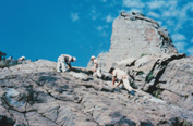
*Scene of ground survey
If you create a geological plan, you can automatically create a cross-sectional view, but that is only a temporary diagram. In order to make this more accurate, we will conduct "boring surveys" and "elastic wave exploration." The data obtained will be tabulated for each stratum. If we apply this to the data patterns of the thousands of tunnels that have been built in Japan, we will be able to determine what kind of stratigraphic structure the strata have, and how to dig a tunnel that is appropriate for that stratum. . Companies such as JR, the Steel Construction Corporation, the Japan Highway Corporation, the Ministry of Construction, and electric power companies have these patterns, and each has its own patterns based on its own data. Tunneling is completely a matter of "empirical engineering," and once a certain value is determined through a survey, the construction method that applies to that value is determined based on empirical rules.
The geological survey before deciding on the tunnel route is called a ``research survey''. Initially, it is called physical exploration because it uses physical methods to cover a wide area, and methods such as elastic wave exploration and electrical exploration are often used. Geophysical exploration is an investigation of a surface, and boring is an investigation of a point. Elastic wave exploration involves creating vibrational waves at one point in the geological strata that you want to investigate, such as by exploding gunpowder, and capturing the vibrations that bounce off the geological boundaries off the ground using a receiver at another point. It explores the actual state of the strata by looking at speed and patterns. Dynamite is often used as the epicenter of elastic waves. Elastic waves are proportional to the hardness of the stratum; the harder the stratum, the faster the waves propagate and the smaller the amplitude. Conversely, if the stratum is soft, the amplitude will be large and the waves will propagate slowly.
Vibration waves are reflected from the surfaces of strata with different hardnesses. Even within the same stratum, the hardness of the strata differs depending on the formation process. If different strata have the same hardness, there will be no reflection from the interface between them. If there is a fault, it will naturally be reflected from there as well. ``Hydrological surveys'' investigate the movement of water within geological formations. For physical exploration, we will use a method called electrical exploration. If you make one point on the earth's surface a positive pole and the other a negative pole, and then run electricity underground, the waveform of the current changes depending on the water in the ground. This allows us to see where water is stored and where there are underground water veins. When digging tunnels in the mountains, there is often standing water underground, which can lead to flooding accidents. For this reason, electrical surveying will be carried out throughout the mountain to check for the presence of water. Electrodes will be set up like needle mice all over the mountain. Once we know where there is likely to be standing water, we can confirm it by boring.
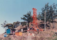
*Boring survey on land
The locations for boring survey (see photo) are selected from those considered necessary to create a cross-sectional view of the strata.
In some cases, it is unclear at what angle the strata that are exposed on the earth's surface enter the earth, and there may be faults that are not exposed on the earth's surface. A fault is a break in the strata due to crustal movement such as an earthquake. It is not possible to determine where the fault lies just by surveying the ground surface. The biggest problems in tunnel construction are water and faults. Do some boring to find out where it is. Research in the ocean cannot be done on foot like on land.
Therefore, we will conduct sonic exploration first. The epicenter is placed behind the research vessel, and a vibration wave receiver is placed floating behind it. Vibration waves from underwater explosions are reflected back to the ocean floor and the strata beneath the ocean floor. This allows us to investigate underground structures in the same way as on land. Typical sound sources include electrical signals and methods that eject pressured gas (water guns). The signals bouncing off each boundary are recorded, and when applied to past patterns, the approximate structure can be determined. Dredging is performed in parallel to this.
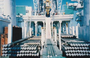
This involves lowering a steel cylinder approximately 50cm in diameter and approximately 3m in length to the ocean floor, and dragging it with a ship to collect samples of rocks on the surface. Do this for the same area as the sonic survey. The tests were conducted at approximately 500 locations in the Tsushima Strait. Furthermore, we conduct ocean boring in areas where there are abnormalities or faults. Boring investigation (all-core boring) involves digging underground with a hollow pipe and extracting a sample of the strata at that location. This sample is called the "core." When drilling for oil wells or hot springs, all you have to do is hit the target oil layer or hot spring, but in the case of geological surveys, the goal is to collect the core during the process, so you have to be careful when digging. At the end of the rotating pipe is a blade covered with industrial diamonds. So if you dig 500m, you can get a maximum of 500m of core. Normally, the core is excavated by digging 3m. The average diameter of the core is 7.5 cm.A thick pipe is used at first, and the pipe becomes thinner as it goes forward, so the core gradually becomes thinner.
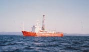
In the case of the ocean, a research vessel dedicated to boring (see photo) will be used. At that time, Japan owned one ship, Tokai Salvage, but it was scrapped after investigating the Japan-Korea tunnel in the Tsushima Strait. At sea, four wires are extended from the research vessel, and a huge weight called an anchor ring is buried in the ocean floor to prevent the ship from moving forward, backward, left or right. When I went drilling in South Korean waters off the coast of Tsushima, the current was so fast that one of my wires broke. The most difficult thing is dealing with vertical fluctuations.
For this reason, the boring machines installed on board ships are designed to withstand vertical movement.
It has a strong spring that absorbs vertical movement. Off the coast of Tsushima, it took 40 days to dig 500m below the seabed at a depth of 150m. This number of days is about the same as on land. Once the data is collected and a geological map is created, the tunnel route will be selected based on it. Technically speaking, topography, geology and construction methods are issues. If there are faults or flooding, construction becomes difficult and costs increase accordingly, so the route is chosen to dig through as stable a stratum as possible. However, in reality, administrative conditions are also subject to consideration.
construction survey of Japan-Korea tunnel
Overview of the Japan-Korea tunnel
![]()