◆Iki has finished cutting down standing trees and is waiting for precision surveying Iki
was able to prepare the tunnel site early, but the construction was scheduled for the latter half of the year, so we have not been able to keep up with the progress in Karatsu and Tsushima until now. I've been watching over you. Last summer, a wellhead was installed in Tsushima, so it was finally Iki's turn. The felling of standing trees on the site, which had been in a state of disrepair, has been completed, and precision surveying is scheduled to be carried out this year in preparation for the installation of the mine entrance. please see last year's ``Genba News'' November and December issues
The next photo is the view from Takenotsuji, Iki's highest peak (213m) in the southern part of the island.
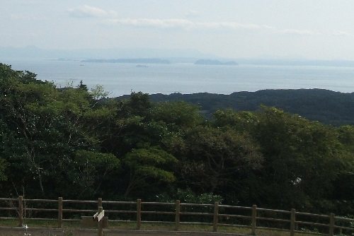
The gourd-like island is Matsushima, and the main tunnel is planned to pass under it. The island on the left is Gadang Island, the island where King Muryeong was born. [Photo] Karatsu seen from Takenotsuji in Iki. Beyond Matsushima and Katara Islands lined up in the center is the Karatsu Nagoya Diagonal Shaft.
The tunnel will run along the east coast from the southeastern part of Iki, then west from the northern part of the island, heading for Tsushima, 50 kilometers away. Unfortunately, Iki Island is not large, so the tunnel cannot come out above ground. The Obon-shaped island, which has no high mountains, is rich in agricultural land and once had the highest rice yield in Nagasaki Prefecture. However, when the Mongolian army attacked during the Kamakura period, the islanders had no place to escape and were annihilated. .
If you turn north, you can see Tsushima 50 kilometers away. That's the next photo. Compared to Iki Island, which is 17 km from north to south, Tsushima, which is 80 km long, lies in a strip across the horizon, albeit slightly.
The sea that runs from Iki to Kyushu feels calmer than the turbulent Tsushima Strait, like an inland sea, and the ancient people who crossed it in small boats must have felt relieved, ``We're almost there!'' On the other hand, when crossing to Tsushima, you can see how they waited for the wind and waves to become calm and prayed for a safe voyage.
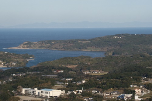
[Photo] Tsushima seen from Takenotsuji, Iki. A thin strip of island shadow can be seen along the horizon.
Iki and Tsushima were the main routes connecting Japan to the peninsula and the continent. In the 3rd century ``Gishi Wajinden'', there is a description of ``Isshikoku'' (Iki Province). The Harunotsuji Ruins, a ring-moated ruin in Yayoi located in the southeastern part of the island, has been designated as a national treasure and a special historic site of the country, and is known to be the royal capital of the Ichishu Province.
On a small hill overlooking the ruins, there is the Isshikoku Museum, which opened in March 2010 and is the posthumous work of architect Kisho Kurokawa. Additionally, in December 2013, the remains of an above-ground iron manufacturing furnace were excavated at the Karakami ruins, and it was Japan's first smelting furnace, where swords, spades, and hoes were made, and advanced technology was used during the Yayoi period. It is becoming clear that
In addition, in the middle of Iki Island, there is Tsukuyomi Shrine, which is said to be Japan's oldest shrine and enshrines Tsukuyomi no Mikoto, which later became Matsuo Taisha in Kyoto, and shrines spread across the country. It has been. Tsukuyomi-no-Mikoto is compared to the moon as the god in charge of the night, and along with Amaterasu Omikami and Susanoo-no-Mikoto, who control the day, this island is important for understanding the Kojiki. It's Iki.
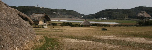
[Photo] Yayoi's ring moat ruins "Haranotsuji ruins" and "Isshikoku Museum" standing on a small hill (upper left back)

![]()